
Space-Based Detection of Sinkhole Activities in Central Florida
InSAR detection of sinkhole activities
Space-borne InSAR is a very powerful technique that is capable of detecting small surface displacements (millimeter level) over wide areas. The method compares pixel-by-pixel SAR phase observations of the same area acquired at different times from roughly the same location in space to produce high spatial-resolution surface change maps. InSAR has been successfully used to monitor land subsidence both in urban (e.g., Amelung et al., 1999; Bawden et al., 2001; and rural areas (e.g., Baer et al., 2002; Galloway et al., 1998; Hoffmann et al., 2003) due to natural or anthropogenic causes, as groundwater withdrawal.
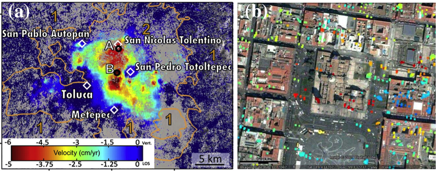
A significant progress in InSAR technology was the development of permanent scatterer Interferometry (PSI) (Ferretti et al., 2000; 2001) and small baseline subset (SBAS) techniques (Berardino et al., 2002; Lanari et al., 2004), which use a large number of SAR observations to monitor displacement time-series using the successive InSAR observations (Figure 1). These techniques are very useful for monitoring slow and continuous deformation of the Earth's solid surface, in particular land subsidence. PSI works well in urban areas and was applied to monitor subsidence in many cities, as New Orleans (Dixon et al., 2006), Mexico City (Osmanoglu et al., 2012), Venice (Bock et al., 2012), and more. The technique is capable of detecting slow movements of individual structures, or even differential section of structure, as we observed in the subsidence of the Mexico Cathedral (Figure 1b - Osmanoglu et al., 2012). The SBAS technique is slightly less precise, but works well in both urban and open areas. It was applied to monitor land subsidence in many locations, as in Italy (Stramondo et al., 2007), Indonesia (Chaussard et al., 2013a), and Mexico (Chaussard et al., 2013b).
|
| Figure 1: InSAR time series detection of land subsidence. (a) Subsidence in and around the town of Toluca, Mexico, as obtain from SBAS anlysis of ALOS data (Source: Chaussard et al., 2013bS). (b) Differential subsidence of the main Cathedral of Mexico City, as obtain from PSI analysis of Envisat data. (Osmanoglu et al., 2011). |
Although the InSAR technique has been available for two decades, it had limited success in detecting sinkhole activity. Several studies detected subsidence in sinkhole-prone areas, such as along the Dead Sea shores (Baer et al., 2002; Closson et al., 2005), Nevada (Al-Fares, 2005), Texas (Paine et al., 2009), Arizona (Conway and Cook, 2013), and Spain (Castaneda et al., 2009). However, successful detection of individual sinkhole subsidence occurred only over large sinkholes (area > 100x100 m2). This limited success reflects most likely the detection limitation of the first two generations of SAR satellites (ERS-1/2, JERS-1, Envisat, and ALOS), which acquire data with 10-20 m pixel resolution.
A significant improvement in SAR satellite detection capability occurred when the third generation of SAR satellites after TerraSAR-X and Cosmo-SkyMed were launched. These current operating satellites have an amazing sub-meter level pixel resolution that is sufficient for detecting surface deformation within small and medium size sinkholes. Recently, Nof et al. (2013) detected precursory subsidence around individual sinkholes along the Dead Sea shores using high-resolution Cosmo-SkyMed observations. Their study shows a gradual surface subsidence in and around sinkholes several months prior to the sinkhole's collapse. The study of Nof et al. (2013) demonstrates that high spatial resolution SAR observations are crucial for detecting small, localized subsidence signal induced by sinkhole activity.